This blog wasn’t the only thing written while we were of no fixed abode.
Here are some articles based on our brewery experiences, published after the trip.
This blog wasn’t the only thing written while we were of no fixed abode.
Here are some articles based on our brewery experiences, published after the trip.
Posted in Uncategorized | Leave a Comment »
So the trip is finished *big sigh*
Over five months we pretty much did a lap of the continent.
We had an outstanding time, saw so many things and met so many people, but it really feels like we only scratched the surface. Don’t be surprised if this website gets resurrected if we find the means to make another trip.
Each post is listed below in the order they were written so you can look back at some of the posts or check them out for the first time. Thanks for reading.
Any questions – feel free to post a comment.
Riversleigh
Fossils
Mt IsaMines
Caption competition result
Heading home for a Christmas surprise
Posted in Uncategorized | Leave a Comment »
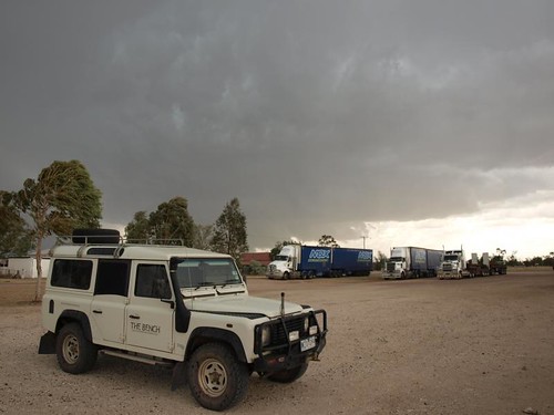
A paper plate is suspended, flattened by the force of the wind against the criss-cross wire fencing around the small park in the tiny border town of Hebel. Nearby, the gazebo above the public barbeque is shaking back and forth. Normally we’d be eating our lunch at a table in a place like this, but the weather is so harsh we’re better off inside THE BENCH, even though it’s swaying gently from side to side.
The excitement of the storm is electric – in more ways than one. We’ve just come charging through the dirt from Brewarrina on the last miles of New South Wales with a drama enacted in the skies around us, cumulonimbus collapsing in the distance like slowing spinning tops. The last thing we wanted was to get stuck in the mud, but incredibly we haven’t seen a drop of rain. It’s a buzz all right.
A big truck arrives from the north. As we’re out watching the storm and taking photographs the driver approaches, his adrenalin-fuelled grin almost as wide as the brim of his cowhide hat. He tells us his story:
“We’re coming down from Roma and the rain got so hard we really needed to stop. But we couldn’t – there’s nowhere to pull over, and if we stopped on the road someone would run up our arse, so we had to keep going. Then we came up behind an oversize load! Oh, it was dangerous, man!” He’s shaken, but clearly excited, and is taking photos of the distant storm with his mobile phone so his mates will believe him.
Then I notice the signpost 50 metres away and think what a fine photo it would make. I wander over and line up the shot, and just milliseconds before the shutter clicks a thunderbolt pierces the grey sky in the distance directly behind the Lighting Ridge sign. It was so nearly a perfect storm photo!
Continuing our journey we see the aftermath of the storms. It’s been rare on our journey to see standing water at the edge of the roads, and so often we’ve been in country that’s crying out for rain. When we reach St George the sun is shining – it’s the calm after the storm. The main road into the town centre is closed as the fire service remove fallen trees from the power lines and the cafes and food shops have closed because there’s no power.
We were experiencing mixed emotions. It was exciting to be almost home for Christmas, and to be setting up this big surprise for Ella’s family who thought we were still thousands of kilometres away in Western Australia. But the excitement was tempered with sadness because we knew our big trip was nearly finished. Still, we were all set to spring our Christmas Day surprise, after we visited just one last National Park.
A little green nugget hanging off the main mass of the Great Dividing Range, Bunya Mountain sticks out of the surrounding farmland like a cool, soothing emerald. We take the road that winds up from Dalby, feeling the temperature drop as soon as we reach the steep slopes and switchbacks and disappear under the cover of trees. And what trees.
There are a select group of pine tree genera that are endemic to Australia and the Bunya Pine is one of these. I’ve often felt that introduced species such as the common plantation pine from California, pinus radiata, look out of place in Australian landscapes. Perhaps it’s because they remind me of the photos of overdressed Outback pioneers posing for photos in their Sunday best despite 40ºC heat – they often seem bedraggled and parched. The Bunya Pines are clearly at home here, though, and their conical domed crowns pepper the hillsides.

Looking up inside the crown of a Bunya Pine
From our campsite among the trees at the top of the hill we see storms passing to the east and west, lighting displays that seem to be at the same altitude as we are, yet they miraculously steer clear of us and we stay dry. In the daytime we tread a few of the bushwalks through the rainforests in the gullies and across the distinctive and curious-looking ‘grassy balds’ – open grass clearings on the hillsides that are the result of centuries of bushfires.
We manage to avoid the two recognised hazards of the area, being bitten by ticks and getting hit on the head by pine cones falling out of the trees. If that sounds completely ridiculous then consider this. The cones are reputed to grow up to the size of a football and can weigh two or three kilos, and the nuts that grow in the cones are as big as brazil nuts! Try sprinkling them on your cereal. Of course, they were a popular source of food for indigenous Australians who came to the mountains to gather them. They ate the nuts raw, toasted or apparently buried them in mud for several months to improve their taste.
On our walks we keep our eyes peeled for any of these immense cones in the undergrowth. They aren’t produced every year, though, so it looks like 2009 wasn’t a good year for pine cones. It was a good year for us, though – a year of exploration and discovery. We ventured beyond the big snake draught excluder of the Great Dividing Range to places we’d often never even read about. We dispelled the myth of the Outback as a singular entity, went out into the country and realised that it is so much more: it is a continent of diversity. Perhaps it doesn’t have the mystique of Asia or the overt cultural manifestations of Europe, maybe much of it is arid and unforgiving and groaning under the weight of its own stereotypes, but there are a remarkable range of landscapes to experience. Yet, after 32 blog posts, five months and 25 000 kilometres travel, and countless breathtaking views there are still many more landscapes that we didn’t see, which is just as well because it gives us the excuse to get out to see them on future trips.
Thanks for taking the time to read. I’ll put together a contents page for the final post here, with links to all the posts for easy navigation.

Flower on the floor at Bunya Mountain National Park
Posted in Uncategorized | Tagged Bunya Mountain National Park, Bunya Pines, Hebel, St George, Storms | 2 Comments »
We gazed briefly at the murky green water of the Darling River from a bridge in the centre of Wilcannia. It was hard to reconcile the black and white photos of paddle steamers and rowing regattas on the interpretative signboards with the little swampy pools in front of us.
The 1500 km long Darling River is the fourth longest river in the land and is part of the Murray-Darling river system. Before there were roads and cars, trucks and trains, it was this river system that really opened up the Outback for settlers, providing a water source and enabling paddle steamers to ferry goods out of the countryside. Towns like Wilcannia, once known as the Queen City of the West, sprouted along the banks. But they’ve wilted now.

Wilcannia - take the time to read a book
Unfortunately rivers aren’t always predictable on the driest inhabited continent – and the fortune of the town has mirrored the ebbing and flowing of the water. The steamers stopped operating between the two world wars, and the Darling was frequently unnavigable when it was open to traffic; it dried up forty-five times between 1885 and 1960. Drought hasn’t been the only problem, though. Too much water is syphoned out for irrigation, it is polluted by runoff from agricultural land, and because the whole catchment sits across state boundaries, it’s fallen prey to political wrangling. It makes for a great case study for getting rid of a whole layer of government! In 2007 the World Wildlife Fund named the Murray-Darling one of the “world’s top ten rivers at risk.” With any luck the Murray-Darling Basin Authority that was formed in late 2008 to provide a single agency for the system’s management will lead to an improved future.

Murray-Darling Catchment
We lurched back onto the dirt to follow upstream the flow of the Darling, the white flour-like bulldust sand exploded under our tyres as if we were driving through a minefield. Although we were passing through pastoral land, there were few signs of life. It was blindingly bright, with scant vegetation to soften the screaming sun.
Since moving to Australia I’ve often looked at a certain page on the map and wondered about one of the towns marked on the Darling. Many other places along the river took names based on the indigenous languages, or were named for prominent people of the era, but this one has the same name as the town where I grew up in England – Louth. It’s hardly unusual for colonialists flung far from their home (and unlikely to ever return) to seek comfort in naming their new patch of dirt for their old one. Australia’s full of such place names. Yet as this name is so familiar, and I have a keen interest in historical geography – how could I stay away?

Bulldust farming
I sought connections between my sleepy hometown Louth, nestled with its Georgian architecture, soaring church spire and markets at the base of the Lincolnshire Wolds, and this Outback Louth. Of course I knew that the Australian Louth would look quite different: one thousand years newer at least, it would be small, down at heel and stuck to its source of life – the river – like a limpet. Dirt roads would lead in from all directions and only a short central section through the settlement would be bitumen sealed.

Outback post box - with water for the postie?
I wanted to find out more about the naming. Had the founder chosen Louth simply to remind him of home or was it aspirational; had he hoped to recreate a bustling market town on the banks of the Darling?
Like Wilcannia, there’s not much left of Louth. The solid square-cornered brick house that is the former post office speaks of past prosperity, although there’s none of the sandstone splendour we’d seen downstream. Apparently there were many pubs in town at one time, but now there’s just Shindy’s Inn. It seems like the place to find out more about the local history.
When we get there it’s empty, but open. Clad in corrugated iron, it has the hallmarks of an Outback Pub. In all three rooms photos, jokes and poems are plastered like wallpaper. We get chatting to the woman who runs the pub and discover that she and her husband left a farm to take on the pub. The drought moved them on, but they’re glad they made the decision. She doesn’t seem too interested in my historical fascination, so I start inspecting the walls.
As I scan the faded photos of floods and droughts and the halcyon days when steamers were loaded with bale upon bale of wool from the surrounding farms, I wonder if I can see something behind these images, read something between the lines. Back in Lincolnshire they stopped using the little 11-mile canal at the beginning of the last century. First it was closed for the duration of the First World War, and then in 1920 a massive flood hit the town claiming 23 lives and damaging the infrastructure. That was the death knell. I guess that it would have become unviable by then anyway, out competed by train and truck. And that’s precisely what happened to the Darling at this end of the world only a few years later. Compared with the Louth Navigation, shipping on the Darling was massive and its steamer- towed barges could manage the same load as twenty of today’s semi-trailers. Such tonnage would have dwarfed the British boats.

The Darling at Louth - December 2009
And then I see him. In a small frame on the wall amongst the other bits and pieces, hardly in pride of place, is a Victorian photographic portrait, sepia tone but less weathered by the sun than some of the photos from this decade. I immediately know who it is – Thomas Matthews, the founder of this town. He’s posing, sitting upright with a stern and serious look on his face. It’s the same expression that has convinced generations of people that Victorians had no sense of humour. At this point I’d like to be able to report that the image in the photo winked at me and whispered the name of a pub or a street in my hometown, but I don’t look into his eyes, I move on to read the inscription below:
“Thomas Matthews, known as the King of Louth. Born in County Louth, Ireland.”
Oh, yes. County Louth, Ireland.
Posted in Uncategorized | Tagged County Louth, Darling River, Louth, Wilcannia | 2 Comments »
Reaching a fork in the road, where the Eyre and Lincoln highways meet in a dry and empty landscape, we see a cluster of large concrete water tanks daubed in bright colours and writing. It seems that each year the winner of the local football competition celebrates their victory with paintbrushes. We both experience a slightly odd feeling: a feeling of familiarity, a feeling that we’ve been here before.
And we have. Eighteen months ago we spent a few weeks driving to and around South Australia. Port Augusta looked quite different this time. What seemed a bit run down a year and a half back now seems like a bustling metropolis – not because it’s grown, or because we’ve seen so much since then, but because with a population of 14 000 it’s the biggest town we’ve seen since Albany. The sight of a supermarket can make one giddy, but while Port Augusta proves a useful place to stock up on supplies, we’re drawn to another oasis: Mt Remarkable National Park.
It’s a gem of a place, 50 km south of Port Augusta, and a short distance east of the Stuart Highway (the road from Adelaide to Darwin). Explorer Edward John Eyre named the mountain in 1840 due to the “lofty way it towered above the surrounding hills.”

Towering gum trees
Our memories from our last trip here were so fond that we wanted to come again. Nestled at the foot of the southern Flinders Ranges, Mt Remarkable National Park is a wildlife haven with great walking tracks that run up along the ridges and through the valley, and gnarly old Red River Gums that tower over the picturesque campground.
You might expect that after the novelty of the last few months it would seem somehow less interesting, yet it had actually changed for the good. It was much greener, the river was flowing slowly and birds and wallabies were making the most of this in the driest state in the country.

Remarkably wet!
We just had time to climb up to Black Range lookout. From this lofty point we looked west out over parched fields to the Spencer Gulf.

Wet & Dry
Eric Newby’s The Last Grain Race recounts his 1938 journey as a crew member on a Finnish four-masted barque, one of about a dozen that made the voyage from Europe to Australia and back collecting cargoes of grain from the south and trying to do it in the fastest time possible. The book is a vivid and humorous account of the experience of living and working on these ships – as the title suggests they were on the verge of disappearing into history, overtaken by war and modern technology. Their destination – the source of the grain – was here in the Spencer Gulf of South Australia. Ports still line the Gulf, today, although they don’t seem to be thriving. We don’t hang around to find out, though, because we’re heading inland, weaving through the ranges, along dirt road shortcuts and past tiny rural settlements.

Classic Outback pub
Any doubt about the continued role of grain in this part of the world is dispelled once we steer inland. It isn’t the sight of silos sticking up on the horizon like churches in rural England, or any other visible evidence of harvest, but the smell that brings it home. I’ve never smelt wheat in the air so strongly as in Peterborough South Australia – it’s like being dropped in a giant biscuit barrel.
A sign on the edge of town reminds me a little of the Royal Family – just as they changed their name from Saxe-Coburg-Gotha to Windsor in 1917 to sound a little less Germanic, so Petersburg became Peterborough a year later. That’s not the only thing that reminds me of the monarchy, though. There’s a faded glory to the place that suggests its role has diminished in recent times.
Peterborough was once a rail hub. Three different rail gauges converged here and an unusual turntable was built that catered for them all. The end of the steam age, the change to a standard gauge, and the rationalisation of rail services led to demise of this town. Today there’s a steam heritage museum for enthusiasts.
A little bit of polish and this whole place could be a living museum. The crumbling federation architecture makes it feel like a coma-town rather than a ghost-town. There are several cafes, shops and pubs along the main street through the town centre, but there’s clearly been a contraction in business since well before the GFC. Bright new shop signs indicate those that still trade, but they’re probably outnumbered by those that might as well be mirages to weary nomads – signs are up, but upon arrival it’s clear the business shut down long ago.

Shut up shops in Peterborough

The Federal Hotel, Peterborough
After Peterborough we return to long straight roads, sea views a distant memory, as we head towards the iconic mining town, Broken Hill. I was expecting something like the bland new town of Mt Isa, visited near beginning of our trip, however Broken Hill’s history radiates from the sun-baked colonial architecture in the town centre. It’s impossible to walk for 50 metres without stumbling across a heritage sign showing a 19th century view of the street with an explanation of its significance.
Unfortunately we’ve hit town on a Sunday and several of the attractions we were hoping to visit are closed. A trip out to the Sculpture Symposium is well worth the detour, though. A walking trail winds through the arid landscape to a viewpoint that looks back to town, and against this backdrop sit a dozen sculptures, created by a number of international artists invited here in 1993 to work massive sandstone blocks quarried nearby. It’s a beautiful way to see the desert, the artwork blending so well with its surroundings.

Broken Hill Sculpture Symposium
Back in town it’s impossible to forget what Broken Hill is famous for – many of the street names echo the source of its wealth. They must be useful reminders for high school students learning geology or chemistry: turn left off Crystal Street onto Oxide Street, cross over Argent Street, keep going until you get to Mica Street, then turn left again and cross Sulphide and Bromide streets, before you get to Garnet Street. Once here turn left, pass Cobalt Street and walk to the end of the road. Do you recognise the view? Yes, that’s right, you’re back where you started.

Broken Hill Sculpture Symposium
Posted in Uncategorized | Tagged Broken Hill, Mt Remarkable, Peterborough, Port Augusta, Sculpture Symposium | 1 Comment »
We all know that golf is, well, crazy. Or as Mark Twain said, it’s a good walk spoiled. Neither Ella nor I have ever played golf, well not properly, and neither of us have any inclination to play golf, but as we began our trip back east in earnest we noticed a rather unusual golf course.
We’d already seen a few outback golf courses on our trips. If golf suggests to you a green scene you’d probably be challenged by such courses. Think beige. Think big dusty vistas with distant sun-bleached flags, broken down corrugated iron clubhouses. Think irreverent Aussie humour.
But this course stretched the concept of a golf course, literally. I suppose the longest golf course in the world (1365 km) has to be located somewhere, and it seems that this somewhere is in the middle, and the edges, of nowhere. At least nowhere is what the majority of the Christmas traffic, screaming through the 1200 kilometres of straight hot grey bitumen to travel between Norseman and Ceduna (the next town of any significance) must think this place is.

The Nullarbor links
Specifically, most of the 18 holes are located at roadhouses along the Eyre Highway, the long straight sealed road that connects the western and eastern states. On its way it crosses the notorious Nullarbor Plain and runs close to the epic bay known as the Great Australian Bight. Let’s face it, if you were trying to walk to the next tee, it wouldn’t be the golf that ruined your walk.
The Eyre highway’s westernmost point is at Norseman and most traffic arrives via Kalgoorlie to the north or Esperance to the south. But we came in the back way picking up the Highway 200 kilometres into its stride, at hole 7 – Balladonia. We arrived after a tooth-rattling ride up the bumpy track from Cape Arid National Park. Short cuts out here can be a little misleading – a 300 km dirt track isn’t necessarily quicker than driving double that distance on dirt. And two-dimensional road maps don’t tend to show road conditions in any detail, nor the universal indicator that things are about to change: council boundaries.
After cruising along a wide smooth dirt road, kept in good condition for the trucks that service the well-spaced farms, we breached the border between the Shire of Esperance and the Shire of Dundas. The road narrowed to a rocky track and our driving speed halved as we negotiated the corrugations and picked a safe route. This wasn’t a problem for THE BENCH of course, and our aim to get back to the east coast for Christmas was never supposed to rule out seeing some of the alternative sights.
In 1865 the surveyor E. Alfred Delisser’s account of his ‘journey into the interior of Australia, north-west of the Great Bight’ appeared in the Proceedings of the Royal Geographical Society of London. He described this great swathe of land as “An immense plain … destitute of trees.” The latin for no trees, nullus arbor, morphed into the present day name – the Nullarbor Plain.
Much has happened since Delisser’s prophetic report: cattle and sheep have grazed; horses have been bred for the British Army in India; Aboriginal reserves have been set aside; roadhouses have been built to service the traffic. Yet the area is still considered by most as stark vacant land existing solely as white space on the map separating places.
Fortunately, we’d become a little travel-hardened by now. After driving some long straight stretches of road in the north of WA, where there was far less traffic around, we weren’t oppressed by the emptiness of the landscape. Perhaps we’d been living outside for so long, or spending so much time observing things; our eyes seemed to have sharpened to notice the changes in the vegetation along the way, to appreciate even the seemingly mundane. We had a good time taking it in turns to drive, the passenger snapping blurry photographs of the slightest object of interest.

50 points if you spot a tree!
Eventually, as the day was finally drawing to a close, we arrived at a lookout. Looking over the Madura Pass exceeded expectations. We must have been standing on the edge of an ancient sea cliff, perhaps 40 km from the present day coast. Suddenly there’s a view, a new perspective, topography. Suddenly there’s trees!
But it’s not just the physical landscape that captivates. Earlier in the day, after driving the longest dead straight section of road in the country (the 90-mile straight), we entered a new and unexpected time. There it was, just lying in the middle of the road, a surprise change in time zones. Well, we knew the clocks would change by 1hr 30 mins when we reached South Australia, another 500 km east, but no one had warned us about this preparatory time zone. It isn’t even on a major line of longtitude. The cheek!
As we rumbled along the road, questions about this unusual arrangement surfaced. Did somebody think we need to be eased back into east coast time? How many people actually live in this time zone? – our map only shows three roadhouses before the WA/SA border and to the north lies desert. What, exactly, is the point of it?
We’re obviously not the first to be confused by this. Paying for fuel at one of the roadhouses I noticed the clock showing this strange time. A sign points to the clock, saying: “Yes, this is the correct time.” A second sign points to the first sign. “Yes, the sign is correct.” I felt an incredible urge to ask the man that served me if the second sign is correct. But then I remembered the response I got from a border guard in Europe when I sarcastically suggested that there was another passenger hiding in the boot of the car. Some things are best left unsaid.

A Dingo hunting
After overnighting in the campground at Madura, we pass into South Australia where the highway runs really close by the sea. Just as we’re catching a couple of lean cyclists who are fighting their way through the wind, we take a turn off down a short track, walk 50 metres, witness a scrawny young Dingo attempting to hunt, and look out from the stark beige Nullarbor. The view is equally as challenging, equally isolated and uninhabitable, but so very different. This time the cliffs look over the sea.

A great place to go for a ride?
So once again the Australian landscape has something special up its wizened geological sleeve. As we look from the cliff we’re standing on the world’s largest limestone karst landscape. There are over 250 recorded caves riddled through this apparently empty plain. And while there may not be many trees around there is a remarkable biodiversity.
Out in this wilderness, in the hard arid wind, among the sand and scrub, a 1984 biological survey identified 794 vascular plant species, 56 mammals, 249 bird species, 86 reptile species and 1 frog species … but no golfers.

Bunda cliffs
Posted in Uncategorized | Tagged Golf, Great Australian Bight, Nullarbor Links, Nullarbor Plain | 3 Comments »
So, back to the journey… back to Western Australia…
It had to happen. It was inevitable. If someone had told us before our trip that this was going to happen, we wouldn’t have been surprised. There’s no way we could drive all the way around Australia and not have this happen. The only surprise was the time of day: we would have expected it early in the morning or late in the afternoon – but it’s only 2pm.
Given the high probability of this occurrence, we came prepared. Tucked behind the car seats is a folding army surplus shovel: a tool to ease the problem. And now here I am, shovel in hand, standing at the side of the road, 30 kilometres east of Esperance. Hesitating.
There are over 200 species of marsupial in Australia, and many of them are Kangaroos or Wallabies. In the wild they generally give humans a wide berth, but they’re a serious hazard around roads. Wherever you drive outside the towns and cities, marsupial remains – large, small and in various stages of decomposition – litter the verges.
This dull windy afternoon, as we were making our way along a pine tree lined road towards Cape Le Grand National Park, a medium-sized Western Grey Kangaroo sped from the shelter of the trees on the left, into view and into our path, just metres ahead. Drivers can crash when they swerve to avoid creating roadkill. But a big roo can damage a vehicle and its occupants in an accident. So what did I do?

Western Grey Kangaroo courtesy of http://bird.net.au/
It happened so quickly. Instinct told me to swerve, but instinct isn’t as fast as a two tonne Land Rover in fifth gear. Like two people in a corridor that can’t decide which side to pass each other, we collided. I tried to go left – the direction the roo had come from – but it did the same, pivoting to hop back off the road, to no avail. It disappeared below our sightline; there was a hard clunk against the massive protective roo bar, followed by a scream from Ella. Shocked and horrified we pulled over to the side of the road. In the mirror I saw the poor animal flailing on the roadside, so we raced back to see if there was anything we could do.
Chest heaving, the roo lay stretched out on the verge stunned, eyes open, incapacitated. It wasn’t dead. I looked for signs of a Joey that might have fallen from a pouch, but it looked like the roo was male. A line of blood at the base of his thick tail didn’t bode well. A broken tail would render it immobile if it survived – a sure death sentence. Scenarios flit through my mind. Should I whack it with the shovel and end the suffering quickly? Or maybe the damage isn’t too bad. Should we take him to a wildlife carer? How would we even find one of those anyway?
Our mobile phone had coverage, so I waited at the end of the line as the Ranger at the National Parks headquarters in Esperance tried to find details for a wildlife carer. It felt futile, but we felt we had to try. How could we fit him in the car? Ella began to move things to make room.
Then I heard the sound of crunching gravel. I ran over. The roo’s back legs were pushing and struggling. But it was spinning in circles on the floor. Death throes.
The Ranger came back on the line.
OK, I think I can find someone for you.
Don’t worry, it’s too late. It’s died.
We drove on quietly, subdued by the event.
Posted in Uncategorized | Tagged Cape Le Grand, Esperance, Western Grey Kangaroo | 7 Comments »
Clichés abound at Christmas time. There’s the food and drink, the decorations, the supposed goodwill and, if you’re so inclined, something about a baby being born in a barn. Every family has their own Christmas traditions, but my parents must have been particularly good at weaving suspense into our Christmases, because the element I’ve always most enjoyed at this time of year is that of surprise. Perhaps in this modern age of gift vouchers and instant gratification my favourite part of Christmas is less prominent than it used to be. Time to reinvigorate the festive season.
Over the past few years we’ve developed our own slightly unusual way of enjoying 25th December. Predictably, perhaps, it’s involved shouldering packs fit to give Santa a hernia and heading off into the bush on a long walk. In the last two Christmases we’ve had the company of Ella’s parents, too. So both aspects of this tradition looked set to collapse given that we’ve been doing plenty of long walks anyway and Ella’s folks are on the other side of the country. Well we couldn’t have that.
A couple of weeks ago, lolling around at the campground after climbing a peak of the Stirling Ranges, we hatched a plan for the longest surprise – long in terms of the time we’d have to keep a secret, and in terms of the distance it would require us to travel in order to deliver it.
Suppose we accelerated our travelling speed to warp factor and shimmied through several time zones (one of which we hadn’t even realised existed), 4500 kilometres, and a kaleidoscope of national parks, landscapes and adventures, could we make it to Bundaberg for Christmas day? More importantly, could we do all of this without arousing the suspicions of the most inquisitive species known to humankind … the Mother-in-Law?
Well, hiding near the end of Ella’s parents’ 800 metre long driveway as I upload this post, we can tell you…that it appears that yes, we could indeed spring the longest surprise. We managed to get through an entire fortnight of phonecalls full of little white lies about our location, the weather we were experiencing and our plans for the day. It’s going to be fun to see the reactions of the in-laws!
If you’ve been following our travels then this sudden climax of the no fixed abode adventure may come as a surprise to you, too. But if, by any chance, you’re concerned there’ll be no more content – don’t worry. Over the last couple of weeks, as we sped along the coast, through dusty outback towns, along iconic rivers, and over mountain ranges, we’ve met some great characters, seen some amazing wildlife, plants and weather and taken hundreds of photos. We even discovered a new time zone! Over the coming weeks we’ll be sharing this with you, albeit at a more leisurely pace than it actually unfolded.
Meanwhile, as we head towards the barbeque, seasons greetings to one and all!
Posted in Uncategorized | Tagged SURPRISE! | 13 Comments »
At some indefinable point we finally passed out of the great forests of the southwest. But not before we’d done our duty, like good tourists, and wandered the Valley of the Giants Tree Top Walk situated a short distance east of Walpole. A tree top walk isn’t nearly as difficult as it sounds. The combination of a gently inclining suspended metal walkway and a downward sloping forest floor mean that with minimum effort one is almost tricked into the canopy. You really have to read a sign that says you’re now 40 metres up to believe it. It’s very impressive. It’s even worth the $10 entry fee to walk amongst the crowns of the Red Tingle trees – a huge buttressed species of eucalypts that only still grow in a small area of southwest WA. It is all very slickly presented and is managed by what seems like an army of staff for a national park venture .

Tree top walk
Our next destination, although relatively lacking in trees, took us to even greater heights. Having turned THE BENCH towards the northeast, up came something new, almost as suddenly as we’d left the forests behind. In the distance, beyond vast fields of wheat and the geometric lines of fast-growing plantation eucalypts, appeared a jagged horizon. It looked like an army of giants had pitched huge green tents in the middle of a wide plain.
The original inhabitants, the Mineng and Goreng (of whom we saw no signs), called it Koi Kyeunu-ruff and believed that spirits lived in the misty clouds that envelop the peaks. The explorer, Matthew Flinders, called it Mount Rugged when he sighted it in 1802, but since 1835 it’s been known, rather tamely I think, as the Stirling Ranges (named for the first Governor of Western Australia).

Approaching the Stirling Ranges
It’s hard to overstate just how impressive the ranges are. They impress geologically: the rock is 2500-2900 million year old seabed and was originally part of the huge landmass of Pangea. They impress biologically: with peaks over 1000 metres above sea level the high altitude creates rain that gives life to over 1500 plant species, over 80 of which are not found anywhere else on the planet! That’s a lot of species in anyone’s book, more than all of those found in the British Isles. But does that mean the Stirling Ranges covers a big area? Not compared to national parks like Kakadu. It’s merely 65 km long from east to west, and 25 km wide.

Looking through the trees at another peak
Had we arrived a little earlier in the year the hills would have been carpeted in the blooms of wildflowers. It would have been like Kalbarri but with an alpine twist. We weren’t too concerned, however, as it meant we spent less time taking photos and more time scaling the peaks. Our early starts found us alone at the summits to enjoy the expansive views.

Near the top of Bluff Knoll

Looking across Stirling Ranges from Toolbrunup

Looking towards Bluff Knoll from Toolbrunup
From our bird’s eye view it was difficult to see that there is a problem lurking in the undergrowth of the Stirling Ranges. Whilst it’s true that there are many unique species, they are under threat from phytophthora cinnamomi, commonly known as dieback. It’s a water mould that attacks the roots of plants and it has spread through large areas of the park, replacing the green foliage with the ghostly grey colour of dry decimated vegetation. To protect the remaining intact ecosystems – those that haven’t suffered from dieback – the good people of CALM have designated large areas off-limits to the public.
Before we left the only national park campground in the Stirling Ranges we were talking to the older couple that collected our camping fees. Their badges proclaimed that they were volunteers. We asked whether they had much time to enjoy the ranges. A bit, they said, but not too much, because there’s lots of work for them to do around the place. Especially since the number of full-time staff paid to look after this amazing place has recently halved. There’s one Ranger now.
Posted in Uncategorized | Tagged dieback, Red Tingle, Stirling Ranges, Tree Top walk, Valley of the Giants | 3 Comments »
I’m standing by a coach in a gravel car park in the tiny town of Northcliffe when a an unnaturally smiley middle-aged woman approaches and starts talking to me.
“Here, have some magazines for your bus journey” she says in a cheerful American accent.
I glance at the publications thrust in front of me. The front covers feature images of people silhouetted by sunsets with their arms outstretched.
“No thanks. I just got off the bus and I’m about to walk for a week – I really don’t need any extra weight.” It’s more diplomatic than saying, stuff your religious propaganda!
Without changing her facial expression she switches from spreading the word of the lord, to spreading the word of the Bibbulmun Track.
“Oh, you’re walking the Bib Track? Wow, that’s great. Have you done it before?”
“Erm, no.”
“Oh, you’re gonna love it – it’s great. Have a wonderful time!”
The Bibbulmun Track (named in recognition of the indigenous inhabitants of southern WA) is a 960-kilometre walk, between Kalamunda (east of Perth) and Albany. The current route opened in the mid-‘90s and is marked its entire length with small yellow directional triangles attached to trees and posts, illustrated with an image of a ‘Waugal’ – the indigenous peoples’ creation serpent. We selected a weeklong, 130 km section, between Northcliffe and Walpole, which passes almost exclusively through National Parks.
Previous through walks we’ve enjoyed are elevating experiences, both literally and metaphorically; routes are designed to make the most of spectacular scenery. But because the Bib Track is a long distance route, much of the section we walked took the path of least resistance. This meant the first half of the week was particularly flat. Fortunately the lack of long dramatic views was made up for by numerous quantities of wildflowers and shifting patterns of vegetation – Jarrah, Karri, Banksia and so on.
In the second half of the walk we passed through the Pingerup Plains and along the coast. These powerful landscapes evoked memories of the wilderness of southwest Tasmania. The sprawling plains looked like wild, desolate prehistoric swamplands; places where strange species are found, adapted to the moody storms amongst the swaying grasses and sedge, in the clumps of twisted trees that poke up on the hillocks, and on the granite outcrop mounds that pierce the surrounding sandy soils. The ancient coastline is creased with epic dunes and plunging cliffs, and carpeted in coarse scrub and hardy blooming plants. It is also home to the shipwreck of the Mandalay, swept up by a storm in 1911 and now hidden by the beach that was named for it. Yet we saw no trace of harsh weather that creates these environments: in our seven days walking there was scarcely a drop of rain, only a few sections of track still mildly boggy from winter, and just enough breeze to cool us when the sun shone!

Pingerup plains
Our walks ended each afternoon when we arrived at a three-sided shelter built to sleep a dozen people, complete with picnic table, pit-toilet, rainwater tank (even fireplace and firewood in the areas where fires are safe). These were a joyous place to relax, eat, read, eat … and eat. Carrying eight days worth of food makes you hungry and adds an incentive to reduce the amount of weight to carry the next day.

View from inside Bib shelter
The shelters at Mount Chance and Woolbales had terrific views nearby, at Maringup the shelter was alongside WA’s second largest freshwater lake, and at Dogpool there was a beautiful tannin-stained river in which to swim and wash. Our final night at Mount Clare saw us tucked under mighty Red Tingle trees endemic to a small patch of the south coast of the state.

Sunrise over Lake Maringup
In these shelters we also got to know the characters of the Bib – not in person, because by chance we actually had all of the shelters to ourselves, but through the parallel world of the dual logbooks. The ‘signing-in’ book contains the names, ages, sex and destinations of other walkers as well as the date of their visit, and the ‘guestbook’ allows for the imaginations of walkers intoxicated by copious fresh air and freedom, to run free.
A half-completed book includes two years’ worth of entries, written by hallowed ‘E2Es’ (end to enders – people walking the full length of the track) as well as people like us who are just enjoying a section of the track. The full scale includes brief banal reports to essay-like descriptions of every element of a walker’s day. There are show-offs: “I walked 6km/hr today”, and there are solo walkers who use the book as conversation: “sorry I write so much and it’s not even entertaining. I think it’s the loneliness and this [writing] makes me feel like I’m talking to someone.”
Other contents include poetry (of varying quality), jokes, cartoons, complaints, and messages for other walkers, as well as comments on track conditions, and soliloquies. We read entries from a 13-year-old lad walking the entire route to raise money for a breast cancer charity and many from retirees enjoying an alternative, caravan-free, grey nomadism. There are inspirational stories of broken boots, howling winds and wading through bogs.
Each day we caught up with adventures parallel to our own: adventures that happened yesterday, last week, eighteen months ago. We read how others experienced the same landscape, sometimes from a different direction (not always intentionally in the case of two walkers that apparently walked the wrong way for a day!), often in different conditions, and certainly with a different perspective. There were many messages of thanks to the people of CALM, the Bibbulmun Track Foundation and the sponsors and volunteers that support the track and make it what it is, a remarkable parallel world.

Looking down from Mt Pingerup
Emerging from our weeklong retreat, spent so close to the highways, yet so far from civilisation, we received our last logbook entry over the airwaves the night after finishing, sitting around a campfire in Walpole listening to ABC Radio National!
We had been reading the lengthy daily accounts of Annie Didcott, a 69-year old woman from Canberra who was on the track a week or two before us. The presenter of Saturday Extra, Geraldine Doogue, read out a letter from Annie, singing the praises of the Bibbulmun and the worthiness of the experience as an opportunity to see up close this wondrous part of the world. Geraldine was so impressed she even suggested she might come and try some of it herself.
So it seems, that in small town car parks, on national radio, and even on travel blogs, everyone is championing the way of the Waugal.

Looking towards Long Point
Posted in Uncategorized | Tagged Bibbulmun Track, Mandalay Beach, Northcliffe, Pingerup Plains, Walpole, Waugal | 7 Comments »
stood, stared, walked and drove through lesser known parts of Australia


